Thu, August 27, 2026


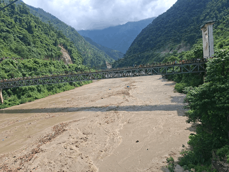
Photo: IANS
The devastating flash floods along the China-Nepal border have raised fresh questions about the forces behind the disaster, after what was initially believed to be an earthquake was later identified as a massive glacial collapse and debris flow.
The floods struck suddenly on Wednesday, causing widespread destruction and casualties and affecting areas near China's Gyirong border port in Tibet. The unusual sequence of events initially led authorities and experts to suspect that an earthquake had triggered the flooding.
Nepal Foreign Minister Shisir Khanal told Parliament that an earthquake was recorded at 8.37 a.m. local time, followed by reports of the flash flood just three minutes later. He cautioned, however, that the information still needed to be verified, The Kathmandu Post reported.
The initial theory appeared plausible because the region is located in one of the world's most tectonically active areas. The US Geological Survey (USGS) initially reported a magnitude 4.4 seismic event in the Tibetan region.
However, subsequent analysis changed the picture significantly.
The International Centre for Integrated Mountain Development (ICIMOD), based in Kathmandu, examined satellite imagery and concluded that a massive rock-and-ice avalanche had occurred in Nepal. The avalanche reportedly blocked the Lhende River and triggered a cascade of flooding downstream.
The USGS later revised its assessment, saying additional analysis of seismic waves and satellite imagery indicated that the signals had been generated by a glacial collapse and debris flow rather than an earthquake.
The development highlights one of the most unusual aspects of the disaster. The movement of huge quantities of ice and rock generated seismic waves strong enough to resemble those produced by an earthquake, potentially confusing early detection systems and officials responding to the emergency.
Scientists are still trying to determine precisely what caused the glacier and surrounding material to collapse. A CNN report said an international team of scientists believes that a large section of a glacier may have broken away from a mountain and plunged into the valley.
One possible explanation is that unusually warm conditions may have accelerated snow and ice melt. The resulting water could have weakened the glacier and contributed to the collapse as the ice moved down an extremely steep slope. However, experts cited by New Scientist cautioned that this may explain only part of the event and that other factors could yet emerge.
The disaster has also generated confusion over its location and possible downstream impact. Chinese media reported that a mudslide occurred in Nepal on Wednesday morning and caused severe casualties near the Gyirong border port in China's Xigaze region of Tibet. The Chinese Embassy in Nepal subsequently clarified that the earthquake-like event or glacial collapse had occurred on the Nepal side and rejected claims that a dam collapse was responsible, calling such reports "fake news".
Beyond the immediate disaster, the incident has renewed concerns about the growing risks posed by a warming Himalayan environment. Glaciers across the region have been retreating rapidly, increasing the possibility of unstable ice formations, landslides and glacial lake outburst floods. Scientists have warned that the interaction between rising temperatures, fragile mountain slopes and rapidly changing glacial systems could make such events increasingly difficult to predict.
The disaster has also highlighted a major gap in cross-border disaster preparedness. Nepal and China have discussed sharing real-time information about floods and landslides and alerting each other to potential glacial lake outburst flood risks. However, according to The Kathmandu Post, a formal mechanism to implement such real-time information sharing has yet to be established, despite Khanal raising the issue during his visit to China in May.
That absence of a functioning early-warning system is particularly significant in the Himalayas, where a disaster originating in a remote mountain valley can cross national boundaries within minutes and leave little time for communities downstream to respond.
The incident therefore presents scientists and authorities with two immediate challenges: establishing what exactly triggered the collapse and improving systems capable of detecting such events before they become catastrophic. It also serves as a reminder that in a rapidly warming Himalayas, not every destructive seismic signal necessarily points to an earthquake.




© Copyright
Reporter Post.All Rights Reserved |
Powered by: Aptilogic Software |
 |
Page rendered in 0.0859 seconds.
|
Page rendered in 0.0859 seconds.