![]()
Wed, July 29, 2026

New Delhi — The upcoming launch of the NASA-ISRO Synthetic Aperture Radar (NISAR) satellite marks a landmark achievement in international collaboration and cutting-edge technology, the Indian Space Research Organisation (ISRO) announced.
NISAR is the first joint Earth observation satellite mission between ISRO and NASA. It is set to be launched next week aboard ISRO’s GSLV-F16 rocket from the Satish Dhawan Space Centre (SDSC-SHAR) in Sriharikota, Andhra Pradesh, at 5:40 p.m. This launch also marks the first time the Geosynchronous Satellite Launch Vehicle (GSLV) will place a satellite into a Sun-Synchronous Orbit (SSO).
Highlighting over a decade of technical collaboration between ISRO and NASA’s Jet Propulsion Laboratory (JPL), ISRO shared on social media platform X:
“Built across continents in phases, NISAR is a result of global teamwork and technology. It came together through years of integration and testing.”
NISAR has achieved several historic firsts:
It is the world’s first dual-band radar imaging satellite.
It is the first GSLV mission to a Sun-Synchronous Orbit.
It is the first joint Earth observation mission between ISRO and NASA.
The GSLV-F16 will place NISAR into a 743 km high Sun-synchronous orbit with a 98.4-degree inclination.
In a post on X, NASA Earth said:
“Two space agencies. One big win for Earth. NISAR is the first time @NASA and @ISRO have built Earth science hardware together. This powerful satellite will track changes on land and ice — from areas prone to landslides and earthquakes to shifting glaciers and ice sheets.”
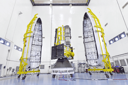
Weighing 2,392 kg, NISAR is a unique Earth-observing satellite equipped with dual-frequency Synthetic Aperture Radar — NASA’s L-band and ISRO’s S-band — both using NASA’s 12-meter deployable mesh reflector antenna, integrated into ISRO’s modified I3K satellite bus.
The satellite will scan the Earth with a 242 km swath at high spatial resolution using advanced SweepSAR technology — a first of its kind.
NISAR will deliver global data every 12 days, day and night, in all weather conditions. This capability will enable applications such as:
Monitoring sea ice and glaciers
Detecting ground deformation
Tracking storm damage and soil moisture
Mapping surface water
Supporting rapid disaster response
According to ISRO, NISAR will be instrumental in enhancing understanding of Earth’s dynamic processes, contributing significantly to environmental management, disaster mitigation, and climate science.
With inputs from IANS


| 14-09-2018 | ||||||
| Sl No. | Parameters | Actual Data(µg/m3) | Standard Limit(µg/m3) |
|---|---|---|---|
| 1 | PM 10 | 64 | 100 |
| 2 | PM 2.5 | 33 | 60 |
| 3 | SO2 | 55.3 | 80 |
| 4 | NO2 | 58.2 | 80 |
| 14-09-2018 | ||||||
| Station | Temperature(degree centigrade) | Rainfall(mm) | Relative humidity(%) | |||
|---|---|---|---|---|---|---|
| Max | Min | Past 24 hrs. | Since 1st March, 2018 | Max | Min | |
| Ranchi | 31.0 | 22.5 | 000.0 | 1010.1 | 95 | 66 |
| Jamshedpur | 34.1 | 26.2 | 000.0 | 1252.8 | 87 | 58 |
| Bokaro | 33.5 | 24.6 | 015.2 | 824.0 | 92 | 79 |
| Daltonganj | 32.6 | 24.9 | 004.2 | 960.9 | 95 | 67 |
© Copyright
Reporter Post.All Rights Reserved |
Powered by: Aptilogic Software |
 |
Page rendered in 0.1041 seconds.
|
Page rendered in 0.1041 seconds.