Sun, September 06, 2026
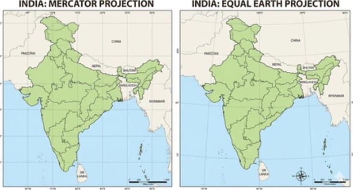
Photo: IANS
The UN General Assembly has backed a new approach to world maps aimed at presenting the relative size of continents and countries more accurately, in a move that has drawn attention to the long-standing distortions of the widely used Mercator projection.
The resolution, supported by India, calls for greater use of the Equal Earth Projection, which represents land areas more proportionately than the Mercator map. It was adopted on Friday with 164 votes in favour, while six countries abstained. The United States was the only country to vote against it.
The Mercator projection, developed by Flemish cartographer Gerardus Mercator in the 16th century, was originally designed primarily for navigation. Its popularity has endured for centuries, but one of its major shortcomings is that it significantly enlarges land masses as they appear farther from the Equator.
This means countries and regions in the northern and southern extremes can appear much larger than they actually are compared with countries closer to the Equator.
Togo, which led the campaign for the change, described the initiative as an effort to correct a long-standing imbalance in the way the world is visually represented.
“Correcting the map means recognising that every region of the world deserves to be represented accurately and with dignity,” Togo's Foreign Minister Robert Dussey said.
For India, the change in appearance is relatively minor. Its overall shape and visual size remain broadly similar, although the peninsula appears slightly less angular and marginally wider on the Equal Earth map.
The difference is much more noticeable for countries such as the United States and Russia. The US appears smaller on an Equal Earth map because its actual land area is much smaller than its familiar Mercator representation might suggest. Russia, which also appears particularly large on Mercator maps because of its high-latitude location, is similarly reduced in apparent size.
The resolution became politically contentious in the United States. Yaryna Ferencevych, a deputy US representative, criticised the initiative, describing it as part of what she called a broader ideological project and arguing that such efforts could undermine the credibility of the United Nations.
Dussey rejected that interpretation, saying the initiative was not intended to target any particular country or cartographic tradition.
“Our approach is not directed against any nation, any civilisation or any cartographic tradition,” he said.
“A fair map does not change the geography of the world; it changes how we see the world,” Dussey added, arguing that a more balanced visual representation could contribute to greater understanding among nations.
Russia, despite appearing considerably smaller on the Equal Earth projection, supported the resolution and characterised it as an anti-colonial initiative.
The resolution, however, is advisory and does not compel governments, schools or institutions to stop using Mercator-based maps. The European Union, which supported the measure, stressed that the resolution is limited to cartographic representation for educational purposes, awareness and geographical literacy.
France has also indicated a move away from relying on Mercator maps. Earlier on Friday, the French Foreign Minister said his country would abandon the projection in favour of maps selected according to their specific purposes and representations that more accurately reflect actual land areas.
The distortion becomes particularly striking when Greenland and Africa are compared. On a Mercator map, Greenland can appear roughly comparable in size to Africa, even though Africa's actual land area is about 14 times larger.
Similarly, Europe can appear larger than South America on a Mercator map, despite South America having roughly 75 per cent more land area.
The Equal Earth projection does not eliminate all distortions — no flat map can perfectly represent the three-dimensional Earth — but it is designed to preserve relative land areas more faithfully.
The UN's move therefore represents less a change in geography than a change in how geographical information is presented, particularly in classrooms and other educational settings where maps can strongly influence people's perception of the relative size and importance of different parts of the world.


© Copyright
Reporter Post.All Rights Reserved |
Powered by: Aptilogic Software |
 |
Page rendered in 0.0749 seconds.
|
Page rendered in 0.0749 seconds.