![]()
Sun, July 26, 2026

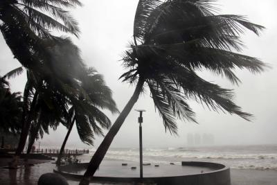
Manila: Tropical Storm Wipha intensified into a severe storm as it moved away from the Philippines on Saturday, lashing several parts of the country — including Metro Manila — with heavy rain and strong winds.
According to the Philippine weather bureau PAGASA, Wipha exited the Philippine Area of Responsibility (PAR) at 10 a.m. local time. The storm is now heading west-northwest toward southern China and is expected to strengthen further, potentially reaching typhoon status by Sunday afternoon or evening.
PAGASA warned that areas exposed to the tropical cyclone may still experience strong winds, especially in coastal and mountainous regions. “Wind signals alert the public to potential wind hazards in areas affected by the cyclone. Local wind conditions may be stronger in elevated or exposed locations,” the bulletin stated.
The National Disaster Risk Reduction and Management Council (NDRRMC) reported that Wipha affected a total of 96,791 people across the country, with several areas experiencing flooding and rain-triggered landslides. Two individuals have been reported missing, according to the agency.
This storm comes months after Super Typhoon Man-yi battered the Philippines in November last year. With winds reaching 195 km/h and gusts up to 240 km/h, Man-yi made landfall in Catanduanes, part of the Bicol region in Luzon. It was the 16th tropical cyclone to strike the country in 2024.
The typhoon hit areas already reeling from a series of five overlapping storms since late October. Government data showed that more than 160 people lost their lives due to flooding and landslides. Millions were displaced, and widespread damage to crops and infrastructure forced several provinces to declare a state of calamity.
On average, the Philippines experiences around 20 typhoons annually, many of which bring destructive rains, winds, and deadly landslides.
With inputs from IANS


| 14-09-2018 | ||||||
| Sl No. | Parameters | Actual Data(µg/m3) | Standard Limit(µg/m3) |
|---|---|---|---|
| 1 | PM 10 | 64 | 100 |
| 2 | PM 2.5 | 33 | 60 |
| 3 | SO2 | 55.3 | 80 |
| 4 | NO2 | 58.2 | 80 |
| 14-09-2018 | ||||||
| Station | Temperature(degree centigrade) | Rainfall(mm) | Relative humidity(%) | |||
|---|---|---|---|---|---|---|
| Max | Min | Past 24 hrs. | Since 1st March, 2018 | Max | Min | |
| Ranchi | 31.0 | 22.5 | 000.0 | 1010.1 | 95 | 66 |
| Jamshedpur | 34.1 | 26.2 | 000.0 | 1252.8 | 87 | 58 |
| Bokaro | 33.5 | 24.6 | 015.2 | 824.0 | 92 | 79 |
| Daltonganj | 32.6 | 24.9 | 004.2 | 960.9 | 95 | 67 |
© Copyright
Reporter Post.All Rights Reserved |
Powered by: Aptilogic Software |
 |
Page rendered in 0.1183 seconds.
|
Page rendered in 0.1183 seconds.